Наука
Разлом Сан-Андреас: редкий случай, когда сценарий фильма превращается в реальность

По сценарию известного фильма-катастрофы, в городе Лос-Анджелес происходит разрушительное землетрясение. Но отличие этого фильма от многих других голливудских фантазий состоит в том, что в Калифорнии действительно существует разлом Сан-Андреас. Этот разлом уже стал причиной нескольких разрушительных землетрясений и, как полагают ученые, от него можно ждать более опасных проявлений уже в ближайшем будущем.
")
Калифорния является одним из самых сейсмически активных регионов США. Именно здесь расположен печально знаменитый трансформный разлом между двумя огромными литосферными плитами: Северо-Американской и Тихоокеанской. Плиты находятся в постоянном движении, а результатом растущего напряжения становятся землетрясения. Разлом начинается в 160 километрах к северу от Сан-Франциско и тянется в направлении юго-востока к Калифорнийскому заливу, проходя прямо под Сан-Франциско и в 40 километрах к северу от Лос-Анджелеса. В районе этого разлома проходит ряд других разломов, образуя густую сеть потенциально опасных геологических образований.


На Тихоокеанском побережье США уже происходили мощные землетрясения, причиной которых послужили движения земной коры, связанные с разломом Сан-Андреас. Последнее крупное землетрясение в Калифорнии произошло в 1989 году, а эпицентром событий стали окрестности горы Лома-Приета. В результате 7-балльного землетрясения сильнее всех пострадал город Санта-Круз, в котором погибли 62 человека и более 3,5 тысяч получили ранения.

В 1906 году произошло землетрясение магнитудой 7,7, эпицентр которого располагался в 3-х километрах от Сан-Франциско. В результате горизонтальных смещений образовались трещины до 8 метров шириной. В ходе многочисленных разрушений погибли около 3 000 жителей Сан-Франциско и близлежащих поселений, а более 80% всех зданий города пострадало в результате стихии.

Ситуация осложняется тем, что Тихоокеанское побережье США является самым густонаселенным регионом страны. В штате Калифорния (по состоянию на 2015 год) проживали 39 миллионов человек. Разлом Сан-Андреас проходит в непосредственной близости от городов Лос-Анджелес (с населением 3,8 миллиона человек) и Сан-Франциско, в котором проживают более 800 тысяч человек. В потенциальной опасности находится и множество других населенных пунктов, которые расположены в южной части Калифорнии.

Американские геологи полагают, что в ближайшем будущем в Калифорнии должно произойти сильнейшее землетрясение интенсивностью не менее 7-ми баллов. Связаны такие опасения с тем, что южная часть разлома Сан-Андреас давно не проявляла мощной активности, хотя небольшие колебания земной поверхности регистрируются в регионе регулярно. При длительных перерывах между сильными землетрясениями в литосфере накапливается колоссальное количество энергии, требующей разрядки. Очередное землетрясение, по мнению сейсмологов, затронет Лос-Анджелес, что повлечет за собой человеческие жертвы и нанесет значительный ущерб инфраструктуре региона.

Материал является авторским, при копировании ссылка на статью или сайт travelask.ru обязательна
Присоединяйся к нашему сообществу в телеграмме, нас уже более 1 млн человек 😍
Ссылка на тематические чаты тут https://t.me/+69dR1AvDfdM0MTYy
 По сценарию известного фильма-катастрофы, в городе Лос-Анджелес происходит разрушительное землетрясение. Но отличие этого фильма от многих других голливудских фантазий состоит в том, что в Калифорнии действительно существует разлом Сан-Андреас. Этот разлом уже стал причиной нескольких разрушительных землетрясений и, как полагают ученые, от него можно ждать более опасных проявлений уже в ближайшем будущем.

Калифорния является одним из самых сейсмически активных регионов США. Именно здесь расположен печально знаменитый трансформный разлом между двумя огромными литосферными плитами: Северо-Американской и Тихоокеанской. Плиты находятся в постоянном движении, а результатом растущего напряжения становятся землетрясения. Разлом начинается в 160 километрах к северу от Сан-Франциско и тянется в направлении юго-востока к Калифорнийскому заливу, проходя прямо под Сан-Франциско и в 40 километрах к северу от Лос-Анджелеса. В районе этого разлома проходит ряд других разломов, образуя густую сеть потенциально опасных геологических образований.


Разлом Сан-Андреас: редкий случай, когда сценарий фильма превращается в реальность
На Тихоокеанском побережье США уже происходили мощные землетрясения, причиной которых послужили движения земной коры, связанные с разломом Сан-Андреас. Последнее крупное землетрясение в Калифорнии произошло в 1989 году, а эпицентром событий стали окрестности горы Лома-Приета. В результате 7-балльного землетрясения сильнее всех пострадал город Санта-Круз, в котором погибли 62 человека и более 3,5 тысяч получили ранения.

Последствия землетрясения Лома-Приета в 1989 году
В 1906 году произошло землетрясение магнитудой 7,7, эпицентр которого располагался в 3-х километрах от Сан-Франциско. В результате горизонтальных смещений образовались трещины до 8 метров шириной. В ходе многочисленных разрушений погибли около 3 000 жителей Сан-Франциско и близлежащих поселений, а более 80% всех зданий города пострадало в результате стихии.

Последствия землетрясения 1906 года в Сан-Франциско
Ситуация осложняется тем, что Тихоокеанское побережье США является самым густонаселенным регионом страны. В штате Калифорния (по состоянию на 2015 год) проживали 39 миллионов человек. Разлом Сан-Андреас проходит в непосредственной близости от городов Лос-Анджелес (с населением 3,8 миллиона человек) и Сан-Франциско, в котором проживают более 800 тысяч человек. В потенциальной опасности находится и множество других населенных пунктов, которые расположены в южной части Калифорнии.

Лос-Анджелес
Американские геологи полагают, что в ближайшем будущем в Калифорнии должно произойти сильнейшее землетрясение интенсивностью не менее 7-ми баллов. Связаны такие опасения с тем, что южная часть разлома Сан-Андреас давно не проявляла мощной активности, хотя небольшие колебания земной поверхности регистрируются в регионе регулярно. При длительных перерывах между сильными землетрясениями в литосфере накапливается колоссальное количество энергии, требующей разрядки. Очередное землетрясение, по мнению сейсмологов, затронет Лос-Анджелес, что повлечет за собой человеческие жертвы и нанесет значительный ущерб инфраструктуре региона.

Проявление разлома Сан-Андреас в рельефе местности
Материал является авторским, при копировании ссылка на статью или сайт travelask.ru обязательна
Источник: http://travelask.ru/blog/posts/11209-razlom-san-andreas-redkiy-sluchay-kogda-stsenariy-filma-prev
From Wikipedia, the free encyclopedia
| San Andreas Fault | |
|---|---|

The fault (right) |
|

Arrows show relative motion of the North American Plate (southeastward) and the Pacific Plate (northwestward) |
|
| Named by | Andrew Lawson |
| Year defined | 1895 |
| Coordinates | 35°07′N 119°39′W / 35.117°N 119.650°WCoordinates: 35°07′N 119°39′W / 35.117°N 119.650°W |
| Country | United States (extends into Mexico) |
| State | California (portions in Baja California and Sonora) |
| Cities | San Francisco, San Bernardino, San Juan Bautista |
| Characteristics | |
| Segments | Calaveras, Hayward, Elsinore, Imperial, Laguna Salada, San Jacinto |
| Length | 1,200 km (750 mi) |
| Displacement | 20–35 mm (0.79–1.38 in)/yr |
| Tectonics | |
| Plate | North American & Pacific |
| Status | Active |
| Earthquakes | 1857, 1906 ( ≈7.8), 1957 ( 5.7), 1989 ( ≈6.9), 2004 |
| Type | Transform fault |
| Movement | Dextral |
| Age | Neogene-Holocene |
| Orogeny | Gorda-California-Nevada |

Plaque showing location of San Andreas Fault in San Mateo County
The San Andreas Fault is a continental transform fault that extends roughly 1,200 kilometers (750 mi) through California.[1] It forms the tectonic boundary between the Pacific Plate and the North American Plate, and its motion is right-lateral strike-slip (horizontal). The fault divides into three segments, each with different characteristics and a different degree of earthquake risk. The slip rate along the fault ranges from 20 to 35 mm (0.79 to 1.38 in) per year.[1] It was formed by a transform boundary.
The fault was identified in 1895 by Professor Andrew Lawson of UC Berkeley, who discovered the northern zone. It is often described as having been named after San Andreas Lake, a small body of water that was formed in a valley between the two plates. However, according to some of his reports from 1895 and 1908, Lawson actually named it after the surrounding San Andreas Valley.[2] Following the 1906 San Francisco earthquake, Lawson concluded that the fault extended all the way into southern California. In 1953, geologist Thomas Dibblee concluded that hundreds of miles of lateral movement could occur along the fault.
A project called the San Andreas Fault Observatory at Depth (SAFOD) near Parkfield, Monterey County, involved drilling through the fault during 2004–2007 to collect material and make physical and chemical observations to better understand fault behavior.[3]
Fault zones[edit]
Northern[edit]

A map displaying each of the seven major faults in the San Francisco Bay Area, and the probability of an M6.7 earthquake or higher occurring on each fault between 2003 and 2032.
The northern segment of the fault runs from Hollister, through the Santa Cruz Mountains, epicenter of the 1989 Loma Prieta earthquake, then up the San Francisco Peninsula, where it was first identified by Professor Lawson in 1895, then offshore at Daly City near Mussel Rock. This is the approximate location of the epicenter of the 1906 San Francisco earthquake. The fault returns onshore at Bolinas Lagoon just north of Stinson Beach in Marin County. It returns underwater through the linear trough of Tomales Bay which separates the Point Reyes Peninsula from the mainland, runs just east of Bodega Head through Bodega Bay and back underwater, returning onshore at Fort Ross. (In this region around the San Francisco Bay Area several significant «sister faults» run more-or-less parallel, and each of these can create significantly destructive earthquakes.) From Fort Ross, the northern segment continues overland, forming in part a linear valley through which the Gualala River flows. It goes back offshore at Point Arena. After that, it runs underwater along the coast until it nears Cape Mendocino, where it begins to bend to the west, terminating at the Mendocino Triple Junction.
Central[edit]
The central segment of the San Andreas Fault runs in a northwestern direction from Parkfield to Hollister. While the southern section of the fault and the parts through Parkfield experience earthquakes, the rest of the central section of the fault exhibits a phenomenon called aseismic creep, where the fault slips continuously without causing earthquakes. It was formed by a transform boundary.[4]
Southern[edit]


The southern segment (also known as the Mojave segment) begins near Bombay Beach, California. Box Canyon, near the Salton Sea, contains upturned strata associated with that section of the fault.[5] The fault then runs along the southern base of the San Bernardino Mountains, crosses through the Cajon Pass and continues northwest along the northern base of the San Gabriel Mountains. These mountains are a result of movement along the San Andreas Fault and are commonly called the Transverse Range. In Palmdale, a portion of the fault is easily examined at a roadcut for the Antelope Valley Freeway. The fault continues northwest alongside the Elizabeth Lake Road to the town of Elizabeth Lake. As it passes the towns of Gorman, Tejon Pass and Frazier Park, the fault begins to bend northward, forming the «Big Bend». This restraining bend is thought to be where the fault locks up in Southern California, with an earthquake-recurrence interval of roughly 140–160 years. Northwest of Frazier Park, the fault runs through the Carrizo Plain, a long, treeless plain where much of the fault is plainly visible. The Elkhorn Scarp defines the fault trace along much of its length within the plain.
The southern segment, which stretches from Parkfield in Monterey County all the way to the Salton Sea, is capable of an 8.1-magnitude earthquake. At its closest, this fault passes about 35 miles (56 km) to the northeast of Los Angeles. Such a large earthquake on this southern segment would kill thousands of people in Los Angeles, San Bernardino, Riverside, and surrounding areas, and cause hundreds of billions of dollars in damage.[6]
Plate boundaries[edit]
The Pacific Plate, to the west of the fault, is moving in a northwest direction while the North American Plate to the east is moving toward the southwest, but relatively southeast under the influence of plate tectonics. The rate of slippage averages about 33 to 37 millimeters (1.3 to 1.5 in) a year across California.[7]
The southwestward motion of the North American Plate towards the Pacific is creating compressional forces along the eastern side of the fault. The effect is expressed as the Coast Ranges. The northwest movement of the Pacific Plate is also creating significant compressional forces which are especially pronounced where the North American Plate has forced the San Andreas to jog westward. This has led to the formation of the Transverse Ranges in Southern California, and to a lesser but still significant extent, the Santa Cruz Mountains (the location of the Loma Prieta earthquake in 1989).
Studies of the relative motions of the Pacific and North American plates have shown that only about 75 percent of the motion can be accounted for in the movements of the San Andreas and its various branch faults. The rest of the motion has been found in an area east of the Sierra Nevada mountains called the Walker Lane or Eastern California Shear Zone. The reason for this is not clear. Several hypotheses have been offered and research is ongoing. One hypothesis – which gained interest following the Landers earthquake in 1992 – suggests the plate boundary may be shifting eastward away from the San Andreas towards Walker Lane.[8][9]
Assuming the plate boundary does not change as hypothesized, projected motion indicates that the landmass west of the San Andreas Fault, including Los Angeles, will eventually slide past San Francisco, then continue northwestward toward the Aleutian Trench, over a period of perhaps twenty million years.[10]
Formation[edit]
Tectonic evolution of the San Andreas Fault.
The San Andreas began to form in the mid Cenozoic about 30 Mya (million years ago).[11] At this time, a spreading center between the Pacific Plate and the Farallon Plate (which is now mostly subducted, with remnants including the Juan de Fuca Plate, Rivera Plate, Cocos Plate, and the Nazca Plate) was beginning to reach the subduction zone off the western coast of North America. As the relative motion between the Pacific and North American Plates was different from the relative motion between the Farallon and North American Plates, the spreading ridge began to be «subducted», creating a new relative motion and a new style of deformation along the plate boundaries. These geological features are what are chiefly seen along San Andreas Fault. It also includes a possible driver for the deformation of the Basin and Range, separation of the Baja California Peninsula, and rotation of the Transverse Range.
The main southern section of the San Andreas Fault proper has only existed for about 5 million years.[12] The first known incarnation of the southern part of the fault was Clemens Well-Fenner-San Francisquito fault zone around 22–13 Ma. This system added the San Gabriel Fault as a primary focus of movement between 10–5 Ma. Currently, it is believed that the modern San Andreas will eventually transfer its motion toward a fault within the Eastern California Shear Zone. This complicated evolution, especially along the southern segment, is mostly caused by either the «Big Bend» and/or a difference in the motion vector between the plates and the trend of the fault and its surrounding branches.
Study[edit]
Early years[edit]
The fault was first identified in Northern California by UC Berkeley geology professor Andrew Lawson in 1895 and named by him after the Laguna de San Andreas, a small lake which lies in a linear valley formed by the fault just south of San Francisco. Eleven years later, Lawson discovered that the San Andreas Fault stretched southward into southern California after reviewing the effects of the 1906 San Francisco earthquake. Large-scale (hundreds of miles) lateral movement along the fault was first proposed in a 1953 paper by geologists Mason Hill and Thomas Dibblee. This idea, which was considered radical at the time, has since been vindicated by modern plate tectonics.[13]
Current research[edit]
Seismologists discovered that the San Andreas Fault near Parkfield in central California consistently produces a magnitude 6.0 earthquake approximately once every 22 years. Following recorded seismic events in 1857, 1881, 1901, 1922, 1934, and 1966, scientists predicted that another earthquake should occur in Parkfield in 1993. It eventually occurred in 2004. Due to the frequency of predictable activity, Parkfield has become one of the most important areas in the world for large earthquake research.
In 2004, work began just north of Parkfield on the San Andreas Fault Observatory at Depth (SAFOD). The goal of SAFOD is to drill a hole nearly 3 kilometres (1.9 mi) into the Earth’s crust and into the San Andreas Fault. An array of sensors will be installed to record earthquakes that happen near this area.[14]
The San Andreas Fault System has been the subject of a flood of studies. In particular, scientific research performed during the last 23 years has given rise to about 3,400 publications.[15]
The next «Big One»[edit]

A study published in 2006 in the journal Nature by Yuri Fialko, an associate professor at the Cecil H. and Ida M. Green Institute of Geophysics and Planetary Physics at the Scripps Institution of Oceanography,[17] found that the San Andreas fault has reached a sufficient stress level for an earthquake of magnitude greater than 7.0 on the moment magnitude scale to occur.[18]
This study also found that the risk of a large earthquake may be increasing more rapidly than scientists had previously believed. Moreover, the risk is currently concentrated on the southern section of the fault, i.e. the region around Los Angeles, because strong earthquakes have occurred relatively recently on the central (1857) and northern (1906) segments of the fault, while the southern section has not seen any similar rupture for at least 300 years. According to this study, a major earthquake on that southern section of the San Andreas fault would result in major damage to the Palm Springs–Indio metropolitan area and other cities in San Bernardino, Riverside and Imperial counties in California, and Mexicali Municipality in Baja California. It would be strongly felt (and potentially cause significant damage) throughout much of Southern California, including densely populated areas of Los Angeles County, Ventura County, Orange County, San Diego County, Ensenada Municipality and Tijuana Municipality, Baja California, San Luis Rio Colorado in Sonora and Yuma, Arizona. Older buildings would be especially prone to damage or collapse, as would buildings built on unconsolidated gravel or in coastal areas where water tables are high (and thus subject to soil liquefaction). Of the study, Fialko stated:
All these data suggest that the fault is ready for the next big earthquake but exactly when the triggering will happen and when the earthquake will occur we cannot tell. It could be tomorrow or it could be 10 years or more from now.[17]
Nevertheless, in the 16 years since that publication there has not been a substantial quake in the Los Angeles area, and two major reports issued by the U.S. Geological Survey (USGS) have made variable predictions as to the risk of future seismic events. The ability to predict major earthquakes with sufficient precision to warrant increased precautions has remained elusive.[19]
The U.S. Geological Survey most recent forecast, known as UCERF3 (Uniform California Earthquake Rupture Forecast 3), released in November 2013, estimated that an earthquake of magnitude 6.7 M or greater (i.e. equal to or greater than the 1994 Northridge earthquake) occurs about once every 6.7 years statewide. The same report also estimated there is a 7% probability that an earthquake of magnitude 8.0 or greater will occur in the next 30 years somewhere along the San Andreas Fault.[20][failed verification] A different USGS study in 2008 tried to assess the physical, social and economic consequences of a major earthquake in southern California. That study predicted that a magnitude 7.8 earthquake along the southern San Andreas Fault could cause about 1,800 deaths and $213 billion in damage.[21]
Cascadia connection[edit]
A 2008 paper, studying past earthquakes along the Pacific coastal zone, found a correlation in time between seismic events on the northern San Andreas Fault and the southern part of the Cascadia subduction zone (which stretches from Vancouver Island to northern California). Scientists believe quakes on the Cascadia subduction zone may have triggered most of the major quakes on the northern San Andreas within the past 3,000 years. The evidence also shows the rupture direction going from north to south in each of these time-correlated events. However the 1906 San Francisco earthquake seems to have been the exception to this correlation because the plate movement was mostly from south to north and it was not preceded by a major quake in the Cascadia zone.[22]
Earthquakes[edit]
The San Andreas Fault has had some notable earthquakes in historic times:
- 1857 Fort Tejon earthquake: About 350 kilometers (220 mi) were ruptured in central and southern California. Though it is known as the Fort Tejon earthquake, the epicenter is thought to have been located far to the north, just south of Parkfield. Two deaths were reported. Its moment magnitude was 7.9.
- 1906 San Francisco earthquake: About 430 kilometers (270 mi) were ruptured in Northern California. The epicenter was near San Francisco. At least 3,000 people died in the earthquake and subsequent fires. The magnitude was estimated to be 7.8.
- 1957 San Francisco earthquake: A magnitude 5.7 quake with an epicenter on the San Andreas fault in the ocean west of San Francisco and Daly City.
- 1989 Loma Prieta earthquake: About 40 kilometers (25 mi) were ruptured (although the rupture did not reach the surface) near Santa Cruz, California, causing 63 deaths and moderate damage in certain vulnerable locations in the San Francisco Bay Area. Moment magnitude was about 6.9. This quake occurred on October 17, 1989, at approximately 5:04 pm PDT.
- 2004 Parkfield earthquake: On September 28, 2004, at 10:15 a.m. PDT, a magnitude 6.0 earthquake struck the Parkfield area. It was felt across the state, including the San Francisco Bay Area.
See also[edit]
- California earthquake forecast
- Central Valley (California) – flat valley that dominates central California
- Coast Range Geomorphic Province
- Garlock Fault – fault running along the margins of the Mojave Desert of Southern California,United States
- Geologic timeline of Western North America
- North Anatolian Fault – turkish seismic strike slip fault
- San Andreas (film) – 2015 American disaster film by Brad Peyton
References[edit]
- ^ a b «San Andreas Fault Zone». Caltech. Retrieved June 20, 2017.
- ^ «Earthquake Facts». earthquake.usgs.gov. Retrieved May 28, 2016.
- ^ «San Andreas Fault Observatory at Depth». Retrieved May 15, 2018.
- ^ «A slow-motion section of the San Andreas fault may not be so harmless after all». phys.org. Columbia Climate School. February 28, 2022. Retrieved March 1, 2022.
- ^ «Box Canyon, near Palm Springs, California». www.americansouthwest.net.
- ^ Rong-Gong Lin II (October 8, 2010). «San Andreas fault capable of magnitude 8.1 earthquake over 340-mile swath of California, researchers say». Los Angeles Times. Retrieved February 17, 2012.
- ^ Wallace, Robert E. «Present-Day Crustal Movements and the Mechanics of Cyclic Deformation». The San Andreas Fault System, California. Retrieved October 26, 2007.
- ^ Faulds, James E.; Henry, Christopher D.; Hinz, Nicholas H. (2005). «Kinematics of the northern Walker Lane: An incipient transform fault along the Pacific–North American plate boundary». Geology. 33 (6): 505. Bibcode:2005Geo….33..505F. doi:10.1130/G21274.1.
- ^ Busby, C. J. (October 1, 2013). «Birth of a plate boundary at ca. 12 Ma in the Ancestral Cascades arc, Walker Lane belt of California and Nevada». Geosphere. 9 (5): 1147–1160. Bibcode:2013Geosp…9.1147B. doi:10.1130/GES00928.1.
- ^ San Andreas Fault. Geologypage. Retrieved from July 21st, 2020.
- ^ Atwater, T., 1970, Implications of Plate Tectonics for the Cenozoic Tectonic Evolution of Western North America
- ^ Powell, R.E.; Weldon, R.J. (1992). «Evolution of the San Andreas fault». Annual Review of Earth and Planetary Sciences. 20: 431–468. Bibcode:1992AREPS..20..431P. doi:10.1146/annurev.ea.20.050192.002243.
- ^ Mason L. Hill; Thomas Dibblee (1953). San Andreas, Garlock, and Big faults, California. Geological Society of America Bulletin. pp. 443–458. ISBN 978-0-8137-2338-9.
- ^ «San Andreas Fault Observatory at Depth». USGS Earthquake Hazards Program. USGS. Archived from the original on October 1, 2005.
- ^ Gizzi F.T. (2015). «Worldwide trends in research on the San Andreas Fault System». Arabian Journal of Geosciences. 8 (12): 10893–10909. doi:10.1007/s12517-015-1878-4. S2CID 130137757.
- ^ NASA (June 23, 2009). «NASA Radar Provides 3-D View of San Andreas Fault». National Aeronautics and Space Administration. Retrieved February 17, 2012.
- ^ a b «New Scripps study reveals San Andreas fault set for the ‘Big One’«. University of California – San Diego. June 21, 2006. Retrieved March 19, 2022.
- ^ Fialko, Yuri (2006). «Interseismic strain accumulation and the earthquake potential on the southern San Andreas fault System» (PDF). Nature. 441 (7096): 968–971. Bibcode:2006Natur.441..968F. doi:10.1038/nature04797. PMID 16791192. S2CID 4432269.
- ^ Geller, Robert J. (December 1997). «Earthquake prediction: a critical review». Geophysical Journal International. 131 (3): 425–450. Bibcode:1997GeoJI.131..425G. doi:10.1111/j.1365-246X.1997.tb06588.x.
- ^ «New Long-Term Forecast for California». USGS.
- ^ «The ShakeOut Scenario». USGS.
- ^ BSSA (April 3, 2008). «Earthquakes Along The Cascadia And San Andreas Faults May Be Linked, Affecting Risk To San Francisco Bay Region». Seismological Society of America. Retrieved February 17, 2012.
Further reading[edit]
- Akciz, S. O.; Grant Ludwig, L.; Arrowsmith, R. J.; Capaldi, T. N.; Rhodes, E. J. (2023). «Channel Incision Ages to the Rescue: An Improved Age for the Penultimate Earthquake That Ruptured the Carrizo Section of the South-Central San Andreas Fault». Bulletin of the Seismological Society of America. doi:10.1785/0120220189. ISSN 0037-1106. S2CID 255637444.
- Collier, Michael (December 1, 1999). A Land in Motion. UC Press. ISBN 978-0-520-21897-0.
- Stoffer, Philip W. (2005). The San Andreas Fault In The San Francisco Bay Area, California: A Geology Fieldtrip Guidebook To Selected Stops On Public Lands. USGS. General Interest Publication 16.
- Lawson, Andrew Cowper (1908). The California Earthquake of April 18, 1906: Report of the State Earthquake Investigation Commission (PDF). Vol. I. Carnegie Institution of Washington.
- Lynch, David K. (2006). Field Guide to the San Andreas Fault: See and Touch the World’s Most Famous Fault on any one of Twelve Easy Day Trips. Thule Scientific. ISBN 978-0-9779935-0-5. Full color, GPS coordinates.
- Reid, Harry Fielding (1908). The California Earthquake of April 18, 1906: Report of the State Earthquake Investigation Commission (PDF). Vol. II. Carnegie Institution of Washington.
External links[edit]
- The Parkfield, California, Earthquake Experiment USGS
- San Andreas Fault Zone Observatory at Depth at the International Continental Scientific Drilling Program
- The San Andreas Fault by Sandra S. Schulz and Robert E. Wallace
- Complete Report for San Andreas fault zone, Peninsula section (Class A) No. 1c from the USGS
- New Scripps Study Reveals San Andreas Fault Set for the ‘Big One’ Archived 2020-01-30 at the Wayback Machine at the Scripps Institution of Oceanography
- San Andreas Fault at Wallace Creek – Kite Aerial Photography from the USGS
- «Scientists Search for a Pulse in Skies Above Earthquake Country» at JPL
- The Day California Cracks at Bloomberg Businessweek
- Interactive Google Map
- San Andreas Fault in Southern California
- Thule Scientific Interactive Map of the San Andreas Fault
From Wikipedia, the free encyclopedia
| San Andreas Fault | |
|---|---|
|
The fault (right) |
|
|
Arrows show relative motion of the North American Plate (southeastward) and the Pacific Plate (northwestward) |
|
| Named by | Andrew Lawson |
| Year defined | 1895 |
| Coordinates | 35°07′N 119°39′W / 35.117°N 119.650°WCoordinates: 35°07′N 119°39′W / 35.117°N 119.650°W |
| Country | United States (extends into Mexico) |
| State | California (portions in Baja California and Sonora) |
| Cities | San Francisco, San Bernardino, San Juan Bautista |
| Characteristics | |
| Segments | Calaveras, Hayward, Elsinore, Imperial, Laguna Salada, San Jacinto |
| Length | 1,200 km (750 mi) |
| Displacement | 20–35 mm (0.79–1.38 in)/yr |
| Tectonics | |
| Plate | North American & Pacific |
| Status | Active |
| Earthquakes | 1857, 1906 ( ≈7.8), 1957 ( 5.7), 1989 ( ≈6.9), 2004 |
| Type | Transform fault |
| Movement | Dextral |
| Age | Neogene-Holocene |
| Orogeny | Gorda-California-Nevada |
Plaque showing location of San Andreas Fault in San Mateo County
The San Andreas Fault is a continental transform fault that extends roughly 1,200 kilometers (750 mi) through California.[1] It forms the tectonic boundary between the Pacific Plate and the North American Plate, and its motion is right-lateral strike-slip (horizontal). The fault divides into three segments, each with different characteristics and a different degree of earthquake risk. The slip rate along the fault ranges from 20 to 35 mm (0.79 to 1.38 in) per year.[1] It was formed by a transform boundary.
The fault was identified in 1895 by Professor Andrew Lawson of UC Berkeley, who discovered the northern zone. It is often described as having been named after San Andreas Lake, a small body of water that was formed in a valley between the two plates. However, according to some of his reports from 1895 and 1908, Lawson actually named it after the surrounding San Andreas Valley.[2] Following the 1906 San Francisco earthquake, Lawson concluded that the fault extended all the way into southern California. In 1953, geologist Thomas Dibblee concluded that hundreds of miles of lateral movement could occur along the fault.
A project called the San Andreas Fault Observatory at Depth (SAFOD) near Parkfield, Monterey County, involved drilling through the fault during 2004–2007 to collect material and make physical and chemical observations to better understand fault behavior.[3]
Fault zones[edit]
Northern[edit]
A map displaying each of the seven major faults in the San Francisco Bay Area, and the probability of an M6.7 earthquake or higher occurring on each fault between 2003 and 2032.
The northern segment of the fault runs from Hollister, through the Santa Cruz Mountains, epicenter of the 1989 Loma Prieta earthquake, then up the San Francisco Peninsula, where it was first identified by Professor Lawson in 1895, then offshore at Daly City near Mussel Rock. This is the approximate location of the epicenter of the 1906 San Francisco earthquake. The fault returns onshore at Bolinas Lagoon just north of Stinson Beach in Marin County. It returns underwater through the linear trough of Tomales Bay which separates the Point Reyes Peninsula from the mainland, runs just east of Bodega Head through Bodega Bay and back underwater, returning onshore at Fort Ross. (In this region around the San Francisco Bay Area several significant «sister faults» run more-or-less parallel, and each of these can create significantly destructive earthquakes.) From Fort Ross, the northern segment continues overland, forming in part a linear valley through which the Gualala River flows. It goes back offshore at Point Arena. After that, it runs underwater along the coast until it nears Cape Mendocino, where it begins to bend to the west, terminating at the Mendocino Triple Junction.
Central[edit]
The central segment of the San Andreas Fault runs in a northwestern direction from Parkfield to Hollister. While the southern section of the fault and the parts through Parkfield experience earthquakes, the rest of the central section of the fault exhibits a phenomenon called aseismic creep, where the fault slips continuously without causing earthquakes. It was formed by a transform boundary.[4]
Southern[edit]
The southern segment (also known as the Mojave segment) begins near Bombay Beach, California. Box Canyon, near the Salton Sea, contains upturned strata associated with that section of the fault.[5] The fault then runs along the southern base of the San Bernardino Mountains, crosses through the Cajon Pass and continues northwest along the northern base of the San Gabriel Mountains. These mountains are a result of movement along the San Andreas Fault and are commonly called the Transverse Range. In Palmdale, a portion of the fault is easily examined at a roadcut for the Antelope Valley Freeway. The fault continues northwest alongside the Elizabeth Lake Road to the town of Elizabeth Lake. As it passes the towns of Gorman, Tejon Pass and Frazier Park, the fault begins to bend northward, forming the «Big Bend». This restraining bend is thought to be where the fault locks up in Southern California, with an earthquake-recurrence interval of roughly 140–160 years. Northwest of Frazier Park, the fault runs through the Carrizo Plain, a long, treeless plain where much of the fault is plainly visible. The Elkhorn Scarp defines the fault trace along much of its length within the plain.
The southern segment, which stretches from Parkfield in Monterey County all the way to the Salton Sea, is capable of an 8.1-magnitude earthquake. At its closest, this fault passes about 35 miles (56 km) to the northeast of Los Angeles. Such a large earthquake on this southern segment would kill thousands of people in Los Angeles, San Bernardino, Riverside, and surrounding areas, and cause hundreds of billions of dollars in damage.[6]
Plate boundaries[edit]
The Pacific Plate, to the west of the fault, is moving in a northwest direction while the North American Plate to the east is moving toward the southwest, but relatively southeast under the influence of plate tectonics. The rate of slippage averages about 33 to 37 millimeters (1.3 to 1.5 in) a year across California.[7]
The southwestward motion of the North American Plate towards the Pacific is creating compressional forces along the eastern side of the fault. The effect is expressed as the Coast Ranges. The northwest movement of the Pacific Plate is also creating significant compressional forces which are especially pronounced where the North American Plate has forced the San Andreas to jog westward. This has led to the formation of the Transverse Ranges in Southern California, and to a lesser but still significant extent, the Santa Cruz Mountains (the location of the Loma Prieta earthquake in 1989).
Studies of the relative motions of the Pacific and North American plates have shown that only about 75 percent of the motion can be accounted for in the movements of the San Andreas and its various branch faults. The rest of the motion has been found in an area east of the Sierra Nevada mountains called the Walker Lane or Eastern California Shear Zone. The reason for this is not clear. Several hypotheses have been offered and research is ongoing. One hypothesis – which gained interest following the Landers earthquake in 1992 – suggests the plate boundary may be shifting eastward away from the San Andreas towards Walker Lane.[8][9]
Assuming the plate boundary does not change as hypothesized, projected motion indicates that the landmass west of the San Andreas Fault, including Los Angeles, will eventually slide past San Francisco, then continue northwestward toward the Aleutian Trench, over a period of perhaps twenty million years.[10]
Formation[edit]
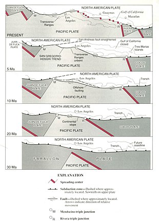
Tectonic evolution of the San Andreas Fault.
The San Andreas began to form in the mid Cenozoic about 30 Mya (million years ago).[11] At this time, a spreading center between the Pacific Plate and the Farallon Plate (which is now mostly subducted, with remnants including the Juan de Fuca Plate, Rivera Plate, Cocos Plate, and the Nazca Plate) was beginning to reach the subduction zone off the western coast of North America. As the relative motion between the Pacific and North American Plates was different from the relative motion between the Farallon and North American Plates, the spreading ridge began to be «subducted», creating a new relative motion and a new style of deformation along the plate boundaries. These geological features are what are chiefly seen along San Andreas Fault. It also includes a possible driver for the deformation of the Basin and Range, separation of the Baja California Peninsula, and rotation of the Transverse Range.
The main southern section of the San Andreas Fault proper has only existed for about 5 million years.[12] The first known incarnation of the southern part of the fault was Clemens Well-Fenner-San Francisquito fault zone around 22–13 Ma. This system added the San Gabriel Fault as a primary focus of movement between 10–5 Ma. Currently, it is believed that the modern San Andreas will eventually transfer its motion toward a fault within the Eastern California Shear Zone. This complicated evolution, especially along the southern segment, is mostly caused by either the «Big Bend» and/or a difference in the motion vector between the plates and the trend of the fault and its surrounding branches.
Study[edit]
Early years[edit]
The fault was first identified in Northern California by UC Berkeley geology professor Andrew Lawson in 1895 and named by him after the Laguna de San Andreas, a small lake which lies in a linear valley formed by the fault just south of San Francisco. Eleven years later, Lawson discovered that the San Andreas Fault stretched southward into southern California after reviewing the effects of the 1906 San Francisco earthquake. Large-scale (hundreds of miles) lateral movement along the fault was first proposed in a 1953 paper by geologists Mason Hill and Thomas Dibblee. This idea, which was considered radical at the time, has since been vindicated by modern plate tectonics.[13]
Current research[edit]
Seismologists discovered that the San Andreas Fault near Parkfield in central California consistently produces a magnitude 6.0 earthquake approximately once every 22 years. Following recorded seismic events in 1857, 1881, 1901, 1922, 1934, and 1966, scientists predicted that another earthquake should occur in Parkfield in 1993. It eventually occurred in 2004. Due to the frequency of predictable activity, Parkfield has become one of the most important areas in the world for large earthquake research.
In 2004, work began just north of Parkfield on the San Andreas Fault Observatory at Depth (SAFOD). The goal of SAFOD is to drill a hole nearly 3 kilometres (1.9 mi) into the Earth’s crust and into the San Andreas Fault. An array of sensors will be installed to record earthquakes that happen near this area.[14]
The San Andreas Fault System has been the subject of a flood of studies. In particular, scientific research performed during the last 23 years has given rise to about 3,400 publications.[15]
The next «Big One»[edit]
A study published in 2006 in the journal Nature by Yuri Fialko, an associate professor at the Cecil H. and Ida M. Green Institute of Geophysics and Planetary Physics at the Scripps Institution of Oceanography,[17] found that the San Andreas fault has reached a sufficient stress level for an earthquake of magnitude greater than 7.0 on the moment magnitude scale to occur.[18]
This study also found that the risk of a large earthquake may be increasing more rapidly than scientists had previously believed. Moreover, the risk is currently concentrated on the southern section of the fault, i.e. the region around Los Angeles, because strong earthquakes have occurred relatively recently on the central (1857) and northern (1906) segments of the fault, while the southern section has not seen any similar rupture for at least 300 years. According to this study, a major earthquake on that southern section of the San Andreas fault would result in major damage to the Palm Springs–Indio metropolitan area and other cities in San Bernardino, Riverside and Imperial counties in California, and Mexicali Municipality in Baja California. It would be strongly felt (and potentially cause significant damage) throughout much of Southern California, including densely populated areas of Los Angeles County, Ventura County, Orange County, San Diego County, Ensenada Municipality and Tijuana Municipality, Baja California, San Luis Rio Colorado in Sonora and Yuma, Arizona. Older buildings would be especially prone to damage or collapse, as would buildings built on unconsolidated gravel or in coastal areas where water tables are high (and thus subject to soil liquefaction). Of the study, Fialko stated:
All these data suggest that the fault is ready for the next big earthquake but exactly when the triggering will happen and when the earthquake will occur we cannot tell. It could be tomorrow or it could be 10 years or more from now.[17]
Nevertheless, in the 16 years since that publication there has not been a substantial quake in the Los Angeles area, and two major reports issued by the U.S. Geological Survey (USGS) have made variable predictions as to the risk of future seismic events. The ability to predict major earthquakes with sufficient precision to warrant increased precautions has remained elusive.[19]
The U.S. Geological Survey most recent forecast, known as UCERF3 (Uniform California Earthquake Rupture Forecast 3), released in November 2013, estimated that an earthquake of magnitude 6.7 M or greater (i.e. equal to or greater than the 1994 Northridge earthquake) occurs about once every 6.7 years statewide. The same report also estimated there is a 7% probability that an earthquake of magnitude 8.0 or greater will occur in the next 30 years somewhere along the San Andreas Fault.[20][failed verification] A different USGS study in 2008 tried to assess the physical, social and economic consequences of a major earthquake in southern California. That study predicted that a magnitude 7.8 earthquake along the southern San Andreas Fault could cause about 1,800 deaths and $213 billion in damage.[21]
Cascadia connection[edit]
A 2008 paper, studying past earthquakes along the Pacific coastal zone, found a correlation in time between seismic events on the northern San Andreas Fault and the southern part of the Cascadia subduction zone (which stretches from Vancouver Island to northern California). Scientists believe quakes on the Cascadia subduction zone may have triggered most of the major quakes on the northern San Andreas within the past 3,000 years. The evidence also shows the rupture direction going from north to south in each of these time-correlated events. However the 1906 San Francisco earthquake seems to have been the exception to this correlation because the plate movement was mostly from south to north and it was not preceded by a major quake in the Cascadia zone.[22]
Earthquakes[edit]
The San Andreas Fault has had some notable earthquakes in historic times:
- 1857 Fort Tejon earthquake: About 350 kilometers (220 mi) were ruptured in central and southern California. Though it is known as the Fort Tejon earthquake, the epicenter is thought to have been located far to the north, just south of Parkfield. Two deaths were reported. Its moment magnitude was 7.9.
- 1906 San Francisco earthquake: About 430 kilometers (270 mi) were ruptured in Northern California. The epicenter was near San Francisco. At least 3,000 people died in the earthquake and subsequent fires. The magnitude was estimated to be 7.8.
- 1957 San Francisco earthquake: A magnitude 5.7 quake with an epicenter on the San Andreas fault in the ocean west of San Francisco and Daly City.
- 1989 Loma Prieta earthquake: About 40 kilometers (25 mi) were ruptured (although the rupture did not reach the surface) near Santa Cruz, California, causing 63 deaths and moderate damage in certain vulnerable locations in the San Francisco Bay Area. Moment magnitude was about 6.9. This quake occurred on October 17, 1989, at approximately 5:04 pm PDT.
- 2004 Parkfield earthquake: On September 28, 2004, at 10:15 a.m. PDT, a magnitude 6.0 earthquake struck the Parkfield area. It was felt across the state, including the San Francisco Bay Area.
See also[edit]
- California earthquake forecast
- Central Valley (California) – flat valley that dominates central California
- Coast Range Geomorphic Province
- Garlock Fault – fault running along the margins of the Mojave Desert of Southern California,United States
- Geologic timeline of Western North America
- North Anatolian Fault – turkish seismic strike slip fault
- San Andreas (film) – 2015 American disaster film by Brad Peyton
References[edit]
- ^ a b «San Andreas Fault Zone». Caltech. Retrieved June 20, 2017.
- ^ «Earthquake Facts». earthquake.usgs.gov. Retrieved May 28, 2016.
- ^ «San Andreas Fault Observatory at Depth». Retrieved May 15, 2018.
- ^ «A slow-motion section of the San Andreas fault may not be so harmless after all». phys.org. Columbia Climate School. February 28, 2022. Retrieved March 1, 2022.
- ^ «Box Canyon, near Palm Springs, California». www.americansouthwest.net.
- ^ Rong-Gong Lin II (October 8, 2010). «San Andreas fault capable of magnitude 8.1 earthquake over 340-mile swath of California, researchers say». Los Angeles Times. Retrieved February 17, 2012.
- ^ Wallace, Robert E. «Present-Day Crustal Movements and the Mechanics of Cyclic Deformation». The San Andreas Fault System, California. Retrieved October 26, 2007.
- ^ Faulds, James E.; Henry, Christopher D.; Hinz, Nicholas H. (2005). «Kinematics of the northern Walker Lane: An incipient transform fault along the Pacific–North American plate boundary». Geology. 33 (6): 505. Bibcode:2005Geo….33..505F. doi:10.1130/G21274.1.
- ^ Busby, C. J. (October 1, 2013). «Birth of a plate boundary at ca. 12 Ma in the Ancestral Cascades arc, Walker Lane belt of California and Nevada». Geosphere. 9 (5): 1147–1160. Bibcode:2013Geosp…9.1147B. doi:10.1130/GES00928.1.
- ^ San Andreas Fault. Geologypage. Retrieved from July 21st, 2020.
- ^ Atwater, T., 1970, Implications of Plate Tectonics for the Cenozoic Tectonic Evolution of Western North America
- ^ Powell, R.E.; Weldon, R.J. (1992). «Evolution of the San Andreas fault». Annual Review of Earth and Planetary Sciences. 20: 431–468. Bibcode:1992AREPS..20..431P. doi:10.1146/annurev.ea.20.050192.002243.
- ^ Mason L. Hill; Thomas Dibblee (1953). San Andreas, Garlock, and Big faults, California. Geological Society of America Bulletin. pp. 443–458. ISBN 978-0-8137-2338-9.
- ^ «San Andreas Fault Observatory at Depth». USGS Earthquake Hazards Program. USGS. Archived from the original on October 1, 2005.
- ^ Gizzi F.T. (2015). «Worldwide trends in research on the San Andreas Fault System». Arabian Journal of Geosciences. 8 (12): 10893–10909. doi:10.1007/s12517-015-1878-4. S2CID 130137757.
- ^ NASA (June 23, 2009). «NASA Radar Provides 3-D View of San Andreas Fault». National Aeronautics and Space Administration. Retrieved February 17, 2012.
- ^ a b «New Scripps study reveals San Andreas fault set for the ‘Big One’«. University of California – San Diego. June 21, 2006. Retrieved March 19, 2022.
- ^ Fialko, Yuri (2006). «Interseismic strain accumulation and the earthquake potential on the southern San Andreas fault System» (PDF). Nature. 441 (7096): 968–971. Bibcode:2006Natur.441..968F. doi:10.1038/nature04797. PMID 16791192. S2CID 4432269.
- ^ Geller, Robert J. (December 1997). «Earthquake prediction: a critical review». Geophysical Journal International. 131 (3): 425–450. Bibcode:1997GeoJI.131..425G. doi:10.1111/j.1365-246X.1997.tb06588.x.
- ^ «New Long-Term Forecast for California». USGS.
- ^ «The ShakeOut Scenario». USGS.
- ^ BSSA (April 3, 2008). «Earthquakes Along The Cascadia And San Andreas Faults May Be Linked, Affecting Risk To San Francisco Bay Region». Seismological Society of America. Retrieved February 17, 2012.
Further reading[edit]
- Akciz, S. O.; Grant Ludwig, L.; Arrowsmith, R. J.; Capaldi, T. N.; Rhodes, E. J. (2023). «Channel Incision Ages to the Rescue: An Improved Age for the Penultimate Earthquake That Ruptured the Carrizo Section of the South-Central San Andreas Fault». Bulletin of the Seismological Society of America. doi:10.1785/0120220189. ISSN 0037-1106. S2CID 255637444.
- Collier, Michael (December 1, 1999). A Land in Motion. UC Press. ISBN 978-0-520-21897-0.
- Stoffer, Philip W. (2005). The San Andreas Fault In The San Francisco Bay Area, California: A Geology Fieldtrip Guidebook To Selected Stops On Public Lands. USGS. General Interest Publication 16.
- Lawson, Andrew Cowper (1908). The California Earthquake of April 18, 1906: Report of the State Earthquake Investigation Commission (PDF). Vol. I. Carnegie Institution of Washington.
- Lynch, David K. (2006). Field Guide to the San Andreas Fault: See and Touch the World’s Most Famous Fault on any one of Twelve Easy Day Trips. Thule Scientific. ISBN 978-0-9779935-0-5. Full color, GPS coordinates.
- Reid, Harry Fielding (1908). The California Earthquake of April 18, 1906: Report of the State Earthquake Investigation Commission (PDF). Vol. II. Carnegie Institution of Washington.
External links[edit]
- The Parkfield, California, Earthquake Experiment USGS
- San Andreas Fault Zone Observatory at Depth at the International Continental Scientific Drilling Program
- The San Andreas Fault by Sandra S. Schulz and Robert E. Wallace
- Complete Report for San Andreas fault zone, Peninsula section (Class A) No. 1c from the USGS
- New Scripps Study Reveals San Andreas Fault Set for the ‘Big One’ Archived 2020-01-30 at the Wayback Machine at the Scripps Institution of Oceanography
- San Andreas Fault at Wallace Creek – Kite Aerial Photography from the USGS
- «Scientists Search for a Pulse in Skies Above Earthquake Country» at JPL
- The Day California Cracks at Bloomberg Businessweek
- Interactive Google Map
- San Andreas Fault in Southern California
- Thule Scientific Interactive Map of the San Andreas Fault
Содержание/сюжет
Рэймонд Гейнс — пилот вертолёта пожарной охраны Лос-Анджелеса Bell 412. Он переживает развод со своей женой Эммой. Одной из причин развода является трагическая гибель их дочери Мэлори во время рафтинга, в которой Рэй винит себя. Вторая его дочь Блэйк, планируя поступить в колледж, отправляется из Лос-Анджелеса в Сан-Франциско на частном самолёте бойфренда матери — Дэниэла Риддика.
Тем временем, сейсмолог Лоуренс Хейс и его помощник Ким Парк, занимающиеся предсказанием землетрясений, близки к прорыву в своих исследованиях. Как раз в этот момент на плотине Гувера регистрируют сильный подземный толчок, и сооружение оказывается уничтожено. В результате обрушения дамбы погибает Ким, а чудом спасшийся Хейс передаёт предупреждение о том, что в разломе Сан-Андреас началось опасное тектоническое движение. Затем мощным землетрясением оказывается разрушен Лос-Анджелес. Рэй, прилетев на вертолёте, успевает спасти Эмму с крыши разрушающегося здания. Он получает звонок от Блэйк о том, что она в Сан-Франциско застряла на обвалившейся подземной парковке внутри автомобиля. Затем связь прерывается. Дэниэл бросает девушку на произвол судьбы, но её спасают братья Бен и Олли Тейлоры.
Рэй и Эмма отправляются в Сан-Франциско. По дороге вертолёт выходит из строя, и они, совершив аварийную посадку на парковку, пробив витрину торгового центра в районе Бейкерсфилда, продолжают путь, забрав автомобиль у мародёров. Путь преграждает колоссальный разлом в земле, и до города они добираются, найдя самолёт. Место встречи, которое предложил дочери Рэй, оказывается недоступно, и он предполагает, что Блэйк будет ждать его в одном из небоскрёбов. Доктор Хейс предсказывает, что подземная стихия затронет весь штат, и следующие толчки разрушат Сан-Франциско. Один из студентов Хейса взламывает сеть телевизионной компании, и доктору с помощью журналистки удаётся передать предупреждение об эвакуации в эфир. Землетрясение магнитудой 9,6 практически полностью разрушает город. Цунами сносит мост Золотые ворота и довершает гибель города. Рэй и Эмма на катере, объезжая город, находят Блейк и братьев Тейлор внутри одного из зданий. Нырнув внутрь, Рэй добирается до дочери и выносит её на поверхность. Спасённые герои покидают город на катере и добираются до временного лагеря для выживших. Последние слова Рэя, который наблюдает картину эпических разрушений: «Мы отстроим всё заново».
Мега-Землетрясение – Мега-Цунами.
Сан-Андреас – Нью-Йорк
© Виктория Попова и Лидия Андрианова
Сегодня разлом Сан-Андреас стал всемирно известным благодаря ожидающейся катастрофе – историческому мега-землетрясению, сопровождающемуся цунами. Однако, внеземные цивилизации и предсказания Эдгара Кейси информируют, что Сан-Андреас – это не отдельное событие, а начало цепи катаклизмов апокалипсиса.
Катаклизмы апокалипсиса, скорее всего, не начнутся в этом году. Эдгар Кейси, как известно, предсказывал, что 44-ый Президент США, которым является Обама, будет последним. Так как выборы 45 Президента США запланированы на 8 ноября 2016 года, то предсказания Кейси о последнем 44 Президенте США означают, что катаклизмы Конца Света должны начаться в этом году.

Несмотря на это предсказание Кейсикатаклизмы апокалипсиса, скорее всего, не начнутся в этом году. Однако, указанная им дата означает, что они стоят уже на пороге.
Э. Кейси и внеземные цивилизации указали одно направление удара. Внеземные цивилизации не указали год начала катаклизмов Конца Света, однако, они представили его полный сценарий. Он включает три всё усиливающихся предварительных катаклизма, которые произойдут в течение года перед началом глобальных. Внеземные цивилизации проинформировали о датах их наступления, эпицентрах и направлениях главного удара, а так же потерях человечества в каждом из них.
Внеземные цивилизации предупреждают, что все три пре-катаклизма будут в виде мега-цунами, а эпицентры первого и второго пре-катаклизмов будут находиться в районе Мексиканского залива.

Как известно, Э. Кейси не только подробно описал направление удара одного катаклизма, очевидно, первого из них, который в виде цунами из Мексиканского залива уничтожит восточную часть Северной Америки. Он так же описал предшествующие ему события, которые позволяют опознать его начало. Эдгар Кейси предсказывал, что«земля подвергнется катастрофическим разрушениям. Во время сильнейшего природного удара в течение нескольких минут воды Мексиканского залива соединятся с Великими озерами, а города западного побережья — Сан-Франциско и Лос-Анджелес — будут разрушены даже раньше городов восточного побережья».
Сан-Андреас – начало апокалипсиса. Следовательно, предсказанное Эдгаром Кейси разрушение западного побережья Америки произойдёт, очевидно, в результате ожидающегося в Калифорнии исторического мега-землетрясения Сан-Андреас. Именно оно будет началом апокалипсиса.
Таким образом, в соответствии с предсказаниями Э. Кейси и информацией внеземных цивилизаций мега-землетрясение Сан-Андреас на западном побережье Америки – это преамбула другого катаклизма, более мощного и разрушительного – первого предварительного катаклизма с эпицентром в районе Мексиканского залива, который в виде мега-цунами, пройдёт уже по восточному побережью США. При этом, мега-землетрясение Сан-Андреас может сразу же перерасти в мега-цунами из Мексиканского залива, или через небольшой промежуток времени.
Разлом Сан-Андре́ас.Близкую реальность начала катастрофы подтверждает критическое состояние тектонического разлома Сан Андреас (theSanAndreasFault), проходящего вдоль западного побережья Северной Америки.

Как отмечают эксперты, разлом полностью подготовлен к масштабному землетрясению.

Как известно, что Сан-Андре́ас — самый протяженный и самый активный в мире тектонический разлом междутихоокеанской исевероамериканской плитами. Глубина разлома достигает около 16 км, а вся его длина – около 1300 км – проходит вдоль побережья штата Калифорния (США), большей частью по суше. Этот разлом начинается в Мексике, пересекает штат Калифорния с юга на север, проходя мимо Лос-Анджелеса, через Сан-Бернардино и Сан-Франциско.

Этот разлом – трансформный, так как две плиты скользят друг вдоль друга. Они смещаются со скоростью, примерно, на 5 см в год. При этом, возле трансформных разломов очаги землетрясений залегают неглубоко, обычно на глубине менее 30 км под поверхностью Земли.

Напряжения, вызванные перемещением плит, поглощаются и накапливаются, постепенно достигая критического значения. Потом, мгновенно, плиты смещаются, горные породы трескаются, и происходит землетрясение с эпицентром на линии разлома.

Учёные предупреждают, что разлом Сан-Андреас «как компьютер загружен и полностью готов к работе», т.е. к исторически мощному мега-землетрясению, сопровождаемому цунами. Как известно, последние крупные землетрясения в разломе Сан-Андреас произошли в 1857 и 1906 гг. Следовательно, продолжительное затишье в этом регионе говорит о том, что напряжение между плитами постоянно нарастает, а выход энергии будет катастрофическим. «Больше века здесь почти тихо, а это очень тревожно», – говорит Томас Джордан, директор Центра землетрясений Южной Калифорнии.

Эксперты предупреждают, что между плитами разлома скопилось огромное напряжение, и высвободившаяся энергия будет сопоставима с ядерным зарядом в сотни мегатонн. Сейсмологи прогнозируют, что сила землетрясения Сан-Андреас может достигнуть 9.2 балла.

Для более точного прогноза состояния Сан-Андреас в мае 2016 года был созван национальный конгресс сейсмологов, результаты которого выразились в проведении расширенных учений с участием Национальной гвардии страны для подготовки к этой катастрофе.
Расширение катастрофы за счёт параллельных разломов. Рядом с разломом Сан-Андреас, параллельно ему, проходят и другие разломы, в том числе, Сан-Габриель и Сан-Хасинто, тоже правосторонние. С разломом связаны землетрясения, достигающие магнитуды 8,1 и вызывающие поверхностные смещения до 7 м.

Учёные считают, что в момент будущего мега-землетрясения параллельные разломы так же могут активизироваться и значительно расширить территорию катастрофы за счёт резонансных землетрясений и усиливающейся нестабильности земной коры планеты.
Часть «Огненного кольца». Кроме того, важно отметить, что всё западное побережье Соединённых Штатов лежит вдоль Тихоокеанского Огненного кольца, практически каждый участок которого, сегодня чрезвычайно активизирован, и готов к действию. Это значительно усиливает вероятность скорого начала землетрясения на разломе Сан-Андреас.
Тихоокеанское вулканическое Огненное кольцо– область на стыке океанических и континентальных плит, в которой расположена большая часть действующих вулканов Земли и происходит наибольшее количество подземных толчков и землетрясений.

Это зона наибольшей сейсмической активности на Земле. Учёные считают, что Огненное кольцо вошло в сейсмически опасный период.

Огненное кольцо – тектонический разлом, который тянется по краям всего Тихого океана от Камчатки через Курилы, Японию, Филиппины и Новую Зеландию, проходит вдоль Антарктики и далее через западное побережье Южной и Северной Америки.

Всего на Тихоокеанском огненном кольце насчитывается 452 действующих наземных вулканов из 540 известных на Земле, т. е. 75% от общего числа активных вулканов нашей планеты. В Тихоокеанском огненном кольце произошло около 90% всех мировых землетрясений и 80% самых мощных в истории.
Эдгар Кейси о затоплении земель Северной Америки и западной Европы.Эдгар Кейси информировал так же о затоплении в это же время оставшихся земель Северной Америки ещё не подвергнутым ударам, а так же западной Европы. «Огромная волна цунами накроет Нью-Йорк и все города Восточного побережья США. И с этого момента начнётся неизбежное затопление водой океанов земель Северной Америки и западной Европы. Большая часть Европы изменится до неузнаваемости в мгновение ока.Под водууйдет западное побережье Англии, Испания, Португалия, часть Японии».
Предсказание Нострадамуса вносит важное предупреждение в описание событий этоговремени: «Общая кровь зальет землю, люди будут жить с закрытыми ртами, и придет непредсказуемое…».Непредсказуемое– эторадиация, неизвестноев товремя явление, которая и закроет рты, заразив воду и пищу.
Радиация на планете возникнет в результате разрушения многочисленных атомных станций сокрушительными ударами стихии. В числе первых, очевидно, будет AЭС Дьябло Каньон (theDiablo Canyon Power Plant), расположенная на полпути между Лос-Анджелесом и Сан-Франциско всего в 2-х милях от мощного разлома Хосгри (theHosgriFault) – компоненты системы разлома Сан-Андреас.

На карте справа показано расположение разлома Хосгри, изображенного оранжевой линией на западной стороне карты, относительно разлома Сан-Андреас, изображенного красным цветом.
Два ключа к символике сознания для чтения сценария и Инструкций для продолжения жизни.В событиях, связанных с огромными человеческими потерями, хаоса быть не должно, так как хаос возникает из-за отсутствия информации и, в данном случае, означает гибель цивилизации. Внеземные цивилизации не допускают такого развития событий. Они передают сценарий, в соответствии с которым будут развиваться все события Конца Света и подробные Инструкции, которые позволят совершить Переход.
Сценарий событий Конца Света внеземные цивилизации представили в многочисленных каменных комплексах-пиктограммах. Однако, они передали информацию символами сознания, непонятными человечеству. Нам Свыше были даны два ключа к чтению этой символики – аналогово-цифровой, а так же закон действия объединённого сознания. Ключи позволили расшифровать многие сотни пиктограмм внеземных цивилизаций, построенных по всему миру и понять этот сценарий. В результате нами составлен «Словарь аналоговых и цифровых символов сознания» внеземных цивилизаций более, чем на 300 символов.

Главное, что одновременно с информацией об уничтожающих катаклизмах, внеземные цивилизации указали человечеству единственный путь спасения. Это – Переход в следующий цикл жизни на параллельный безопасный Высший уровень материального мира в гармонии Земли, где катаклизмов нет. Они передали так же подробные Инструкции, как совершить этот Переход.
Перевернутый крест св. Петра, как предупреждение о необходимости переворота сознания. В ближайшее время на Земле начнутся глобальные катаклизмы в результате расхождения тектонических плит. Внеземные цивилизации указывают лишь один путь продолжения жизни – Переход на безопасный Высший уровень материального мира. Однако, он основан на преобразовании тела с помощью неизвестного человечеству закона действия объединённого сознания. Внеземные цивилизации передали подробные Инструкции, как совершить этот Переход. Объединённое сознание человечества должно зажечь луч лазера невероятной силы, который уничтожит тела на уровне Кристаллических Структур и в то же мгновение произойдёт всеобщее воскресение на Высшем уровне материального мира. Так цивилизация совершит Переход и продолжит жизнь в новом цикле Коррекции.

Создание луча лазера для Перехода возможно только при невероятной сплоченности сознания людей Земли с помощью осознанного переворота сознания с ненависти на любовь и взаимопонимание. О необходимости переворота сознания для продолжения жизни в течение двух тысячелетий предупреждает перевернутый крест св. Петра.
Даты катаклизмов – предупредительная световая сигнализация. Для передачи информации о датах катаклизмов Конца Света, внеземные цивилизации построили на планете комплексы-пиктограммы со световыми эффектами, которые определяют четыре даты смертельно опасные для человечества – дни осеннего и весеннего равноденствий, а так же дни летнего и зимнего солнцестояния. К этим комплексам относятся Стоунхендж и Нью-Грендж, Чавин-де-Уантар, Лох-Крю, Мейсхау, Даут,Наут и другие.

Среди комплексов со световыми эффектами выделяется один – с теневым эффектом спускающегося дракона – символа катаклизма в символике сознания. Этот невероятный эффект возникает на пирамиде Кукулькан в Чичен-Итце, в Мексике дважды в год – в дни осеннего и весеннего равноденствий. Невероятное зрелище привлекает десятки тысяч людей со всего мира.

Так внеземные цивилизации предупреждают людей Земли о самых главных событиях – первом и втором предварительных катаклизмах, в промежутке между которыми человечество должно совершить Переход. Начало второго пре-катаклизма означает гибель цивилизации, так как количество оставшихся после него людей будет уже недостаточно для того, чтобы запустить механизм Перехода.
Даты трёх пре-катаклизмов. Теневой эффект на пирамиде Кукулькан информирует человечество, что первый пре-катаклизм произойдёт в день осеннего равноденствия, а следующий за ним второй пре-катаклизм – в день весеннего равноденствия.
Дата третьего пре-катаклизма не важна, так как судьба оставшегося после второго катаклизма человечества будет уже предрешена. Тем не менее, эта дата так же представлена внеземными цивилизациями – это день летнего солнцестояния. Третий пре-катаклизм, вероятно, будет развиваться по модели русского ученого Николая Жарвина, в соответствии с которой, «катаклизм проявится в виде цепной реакции в глобальной рифтовой системе Земли –– ленте вулканов, которая опоясывает нашу планету через континенты и океаны и составляет около 80.000 км. В результате начнут взрываться вулканы по всей её длине. По всей планете пройдут мега-цунами».

Вскоре начнутся глобальные катаклизмы. Они будут всё усиливаться и продолжаться миллионы и миллионы лет, вплоть до полного разрушения планеты, образ которой сегодня представляет Плутон – ядро, оставшееся от некогда существовавшей планеты, площадь поверхности которой примерно равна площади России.

Сильное землетрясение и цунами у берегов Перу.Внеземные цивилизациипредупреждают, что непосредственно с первым пре-катаклизмом в районе пересечения Эль-Ниньо и течения Гумбольдта, возникнет сильное землетрясение, которое будет сопровождаться цунами.

Разрушение Рима, как замена ключей. Среди уничтожающих ударов Конца Света будет один необычный, о котором проинформировал святой Малахия ещё в 12 веке – разрушение Рима. Этот удар связан с заменой ключей от царства небесного – физических, которыми сегодня владеет папство, на ключи символики сознания, которыми написаны Инструкции для Перехода. Этот ирландский пророк предсказал, что с падением святого града Рима наступит апокалипсис. Св. Малахия пророчествовал: «Во время последних гонений Святой Римской Церкви воссядет Пётр Римлянин, который будет пасти своих овец среди множества терзаний; по свершении чего, Город Семи Холмов будет разрушен, (т. е. Рим будет уничтожен) и беспристрастный Судья будет судить народ Свой. Конец.»

В течение тысячелетий ключи от врат царства небесного принадлежали папству. Однако, уже окончено время совершенствования индивидуального сознания по заповедям и формирования взаимоотношений на планете в соответствии с золотым принципом нравственности – возлюби ближнего твоего, как самого себя. Переход в царство небесное – на Высший уровень материального мира, связанный с преобразованием тела – это экзамен на достижение высшего уровня – объединённого сознания цивилизации, глубина которого определит возможность Перехода. Переход будет происходить по Инструкциям внеземных цивилизаций, написанных символикой сознания. Поэтому замена ключей, означающая переход от индивидуального сознания к объединённому, будет ярко обозначена ударом разрушения их цитадели – Ватикана, расположенного в Риме.
Составленный нами сценарий катаклизмов Конца Света содержит 6 природных ударов невероятной силы перед началом глобальных катаклизмов:
- Мега-землетрясение Сан-Андреас, сопровождаемое цунами на западном побережье Северной Америки. При этом, мега-землетрясение Сан-Андреас может сразу же перерасти в мега-цунами из Мексиканского залива, или через небольшой промежуток времени. Радиация.
- Первый пре-катаклизм –– 22-23 сентября день осеннего равноденствия. Эпицентр – район Мексиканского залива. Направление главного удара – восточное побережье Северной Америки. Затопление водой океанов оставшихся земель Северной Америки и западной Европы. Под водууйдет западное побережье Англии, Испания, Португалия, часть Японии. Сильная радиация на планете из-за разрушения многочисленных атомных станций.
- Разрушение Рима, предсказанное св. Малахия.
- Второй пре-катаклизм – 20 марта день весеннего равноденствия. Эпицентр – район Мексиканского залива. Охватит огромные территории. Огромные человеческие потери. Начало второго пре-катаклизма означает гибель цивилизации,так как количество оставшихся людей уже не сможет запустить механизм Перехода.
- Сильное землетрясение, сопровождающееся цунами, у западного побережья Перу в районе пересечения Эль-Ниньо и течения Гумбольдта, возникнет непосредственно с первым пре-катаклизмом.
- Третий пре-катаклизм – 20-21 июня день летнего солнцестояния.
- Начало глобальных катаклизмов.
Борьба за Западную Сибирь бессмысленна. Эдгар Кейси информировал, что только Россия и особенно Западная Сибирь останется практически не затронутой катаклизмами. Но это только для пре-катаклизмов. Глобальные – охватят всю планету и нигде жизнь не может быть продолжена. Внеземные цивилизации утверждают – либо всё человечество одновременно совершит Переход, либо цивилизация Земли погибнет в глобальных катаклизмах. Следовательно, борьба за Западную Сибирь абсолютно бессмысленна.
Фазы разрушения планет в Солнечной системе. Цель начинающихся глобальных катаклизмов – полное разрушение планеты. Последовательные фазы этого процесса можно легко проследить в Солнечной системе по планетам прошлого развития сознания – в направлении от Земли к Плутону, т.е. в направлении обратном развитию на них сознания.

Результат первой фазы развития глобальных катаклизмов – глубокое ослабление магнитного поля, уход атмосферы, превращение гор в груды песка – в которую входит сейчас Земля, представлен на Марсе. Последняя, заключительная фаза – представлена на карликовой планетеПлутон.
Венера и Меркурий – это планеты, на которых человечество последовательно будет совершенствовать сознание после цикла Коррекции на Высшем уровне материального мира в гармонии Земли. Наш Переход – это первый шаг на пути к жизни на этих планетах.
«Из России придёт спасение мира». Эдгар Кейси предсказывал: «Из России в мир придёт надежда – не от коммунистов, не от большевиков, а из свободной России! Из России надо ожидать спасение мира».
И, действительно, нам, русским ученым, авторам этой статьи,Свыше были даны два ключа к символике сознания. Эти ключи позволили расшифровать подробные Инструкции для Перехода, которые передали внеземные цивилизации, как единственный путь для продолжения жизни при наступлении глобальных катаклизмов. Инструкции позволяют преобразовать тело для Перехода на Высший уровень материального мира.
Основа Перехода – глубокое взаимопонимание и любовь людей планеты, соответствующие принципу – возлюби ближнего твоего, как самого себя. Об этом братстве людей планеты, которое возникнет в период планетарных катастроф, и предсказывал Э. Кейси.
Более подробная информация представлена на нашем канале ourtransition49 на www.youtube.com